Walks Inverness & Loch Ness
Author: John & Trina Wombell
Re-walked by Richard Hallewell & Becky Coope
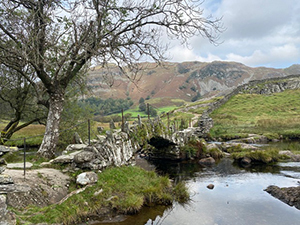
Of all of the areas that we have covered over the years, that covered by Walks Inverness & Loch Ness is perhaps the most varied. It has been a number of years since we were last in the area, the previous rewalk having been carried out by another one of our rewalk teams. The walks featured cover everything from mountain climbs and moorland treks to canal-side paths and city centre strolls. However one of the most memorable things about the area is the abundance of spectacular waterfalls!
One thing that was immediately evident is that the area seems to be thriving. The city itself and surrounding towns and villages are bustling and a considerable amount of money appears to have been spent in recent years on walks, signage etc.
The area is quite large and so the rewalk was carried out over two weeks. The first week in November was a bit of a challenge weather-wise. It started off quite wet which meant fording streams was not easy, however one positive aspect was that the waterfalls were spectacular, especially the Plodda Falls, where a spectacular viewing platform cantilevers over the falls (not great for those who suffer from vertigo!) and the Falls of Foyers, which tumble down into Loch Ness.
The second week in April was dogged by late snow, which made the higher routes interesting!
Other highlights include the walk from South Kessock in Inverness itself – full of interest for those who enjoy boat watching – and the walk at the quiet area of Corrimony, which passes a wonderful chambered cairn, before going on to another spectacular waterfall and also has the potential to extend the walk for some distance on a good track through an RSPB reserve.
There were quite a number of changes to walks, mainly due to new signposting, and the somewhat ubiquitous spread of windfarm, hydro and power line developments which pepper the Highlands these days. The most significant change we made was splitting the walk between Foyers and Inverfarigiag on the south shore of Loch Ness into two routes. There has been quite a lot of new signposting in this area and splitting the route now made sense. In addition, we have drawn attention to the South Loch Ness Trail (which follows a very clear footpath through the hilly land on the quieter side of the loch), and made a number of other alterations to walks where the paths or signposts have changed.
Summing up, there is an excellent range of walks in this area. There are a number of good, well laid out forest walks, thanks to Forestry and Land Scotland, as well as more navigationally challenging routes such as Rhiendown Wood and Loch nam Bonnach outside the city, and the historically significant Corrieyairack Pass, which is a hefty 25 miles/40km one way. Something for everyone. If you have not visited the area before, you will find plenty of interest to keep you walking happily for some time.
For more details or to buy a copy please click here.
Photographs:
centre left: The entrance to the Caledonian Canal
bottom left: The Falls of Foyers